“I know people who lived in Southwest before they threw the colored out and made it for the wealthy” (Jones 147).
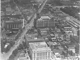
An aerial photo of Washington D.C. (circa 1923).
Social Class, Identity, and the Changing Meaning of Home
At multiple times in Edward P. Jones’s “Lost in the City,” Lydia reiterates variations of the following phrase: “My name is Lydia Walsh and I live in Washington” (149). As if trying to reaffirm her existence and root herself in meaning, Lydia’s repetition of this phrase hints at the important linkage between home and personal identity. Home, as she names it, is the city of Washington D.C. More than that, it is an element of her character, rooted in the histories of her past and the ever-growing experiences of her present.
“My name is Lydia Walsh and I live in Washington” (149).
“Je m’appelle Lydia et j’habite a Washington” (145).
“My name is Lydia… say it loud…” (148).
In some ways, Lydia seems to express the common desire to be “from” somewhere – to attach her origins to the concept of home and to tie that concept to a place. In “Lost in the City,” however, Lydia’s origin story is complicated by the effects of social class and its isolating influence over her childhood homes and her current living situation. Lydia’s various ways of saying that she lives in Washington—including changing the language itself, though never saying she is from the city—embody the complications of origins and the places we inhabit.
In that space between the Washington Lydia is from and the one in which she lives, the consequences of changing social class are emphasized through the fracturing of family structures, the reductive delineations of income, and, perhaps most profoundly, through the reframing of space and the elusive linkage between home and the construction of identity. In crossing boundaries of class, race, and time Lydia intensifies her sense of displacement and, the story therefore alludes to the inevitable disconnect between the idea of home and underlying social factors that threaten its identity.
Within “Lost in the City”, the linkage between social class and home reveals itself through the gradual retracing of Lydia’s life history. Framed geographically as a meandering taxi ride, Lydia’s journey retraces her steps from her current home to a string of her childhood homes in the changing neighborhoods of the Southwest and Northwest sides of the city. The backwards progression of those homes, in turn, points to the ways social class complicates the construction of identity and gives way to the formation (and inevitable displacement) of the places we call home. Tracing her taxi ride geographically helps to group our conceptualization of those displacements and therefore Lydia’s sense of home.

The city of Washington DC is divided into four quarters: Northwest (NW), Northeast (NE), Southwest (SW), and Southeast (SE).
“‘Ma’am maybe you should tell me where you goin?’ the cab driver said.
‘Just get me lost in the city,’ she said” (149).
Although Lydia initially intends to go to the George Washington Memorial Hospital in order to finalize her mother’s death, she ends up directing her driver to “get lost in the city” (148). This is the route he drives.
Mapping Lydia’s Taxi Route in “Lost in the City”
- The route begins at Lydia’s current home, a town house in the Southwest region of DC. NOTE: Although Lydia initially intends to drive to the George Washington Memorial Hospital in order to finalize her mother’s death, she ends up directing her driver to “get lost in the city” (148).
- Prompted by Lydia’s request, the cab driver drives out of her compound and turns right on G Street.
- The cab moves up G Street, towards the federal buildings along 7th Street.
- The cab driver turns right on New York Ave, then quickly makes a left on 5th Street.
- He continues up 5th Street and passes one of Lydia’s childhood homes on 1122 5th Street. This building, as Lydia recalls, is the place where her father died when she was 4 years old.
- The cab then passes the 457 Ridge Street Apartments, where Lydia and her mother lived in a downstairs apartment and met her mother’s best friend, Georgia.
- The cab driver turns right on O Street, the same street that Lydia’s mother lived on while Lydia was going through her last year of law school.
- He then turns left on New Jersey Ave and right at Rhode Island. The story ends with Lydia reminiscing about when she and her mother lived in a large apartment building on Rhode Island, where a Safeway has now taken over.
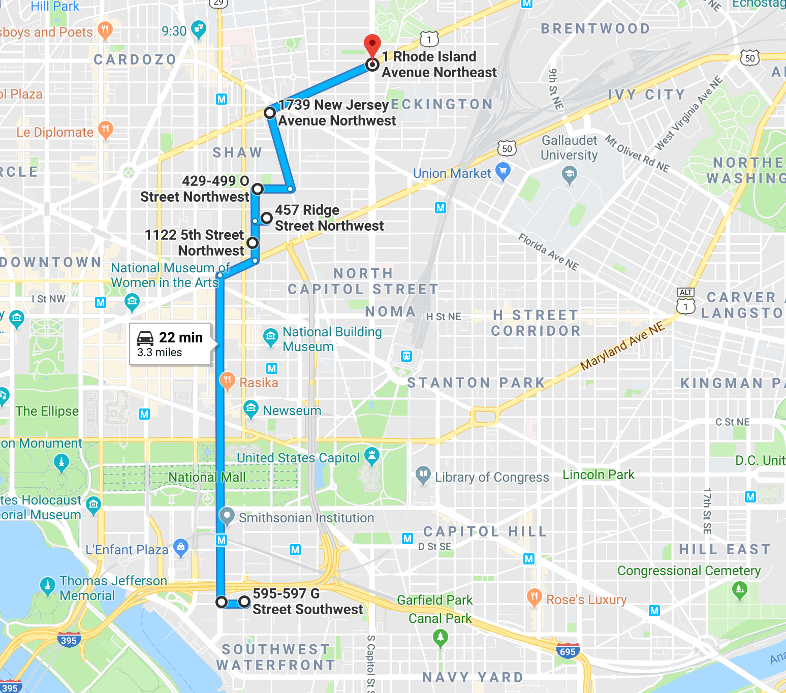
This Google Maps route outlines the path taken by Lydia’s cab driver as he traveled from Lydia’s town house on G Street to her old apartment on Rhode Island Ave, in an attempt to help to follow Lydia’s request to “Just get me lost in the city.”
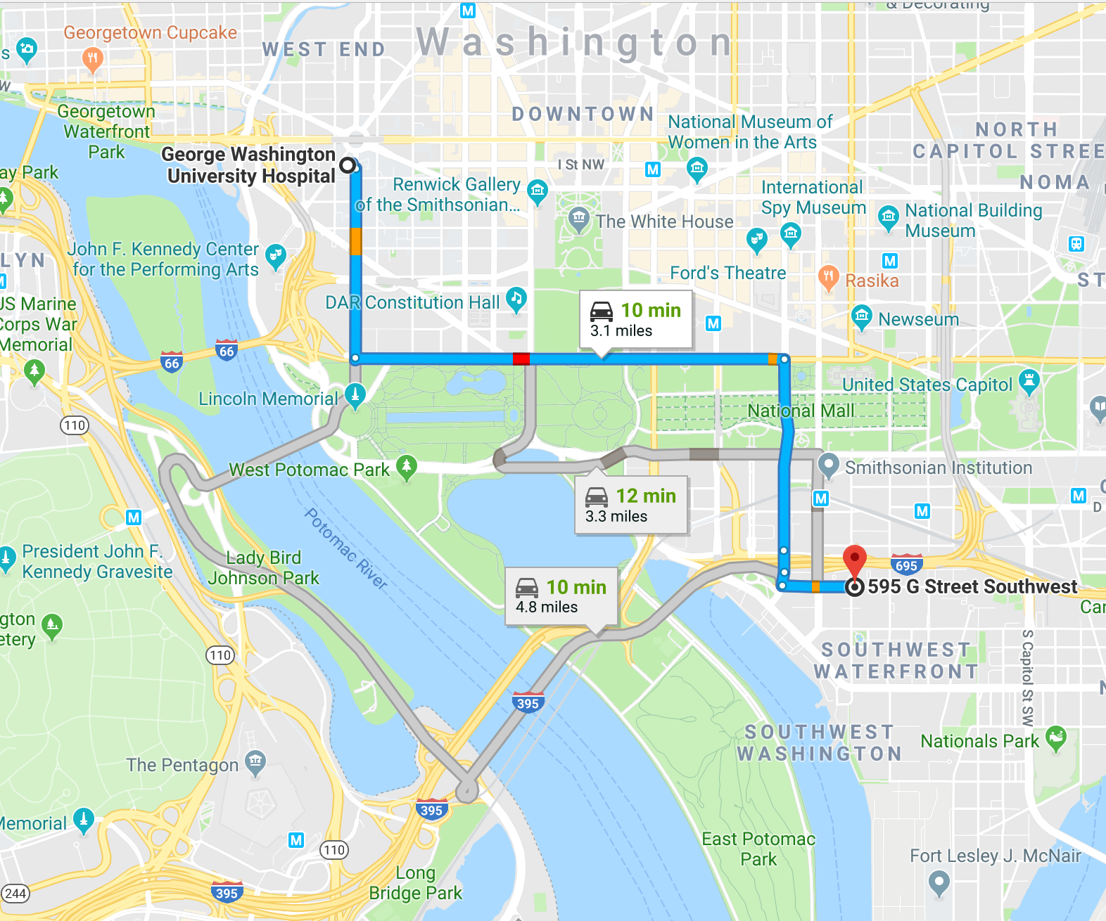
This map shows the route Lydia would have taken from her town house in order to arrive at the George Washington University Hospital, where her mother’s body was waiting.
Using Geography as a Window to the Divisions of Social Class
During the beginning of the taxi drive, Lydia passes the National Mall and its collection of museums. Prompted by the geographic cue, Lydia draws a comparison between her father’s working life and her own profession as a lawyer.
“In one of the museums white men allowed her father to make a living pushing a broom, and now she was paid in one year more than her parents earned in both their lifetimes.” (148)
Comments such as the one outlined above reflect the buildup of tension between Lydia’s adult life as an upper-class, highly-educated professional and her youth, growing up in a lower middle-class family. As Lydia moves throughout the city, she identifies landmarks and connects them to memories of her past.
Through this process of association, Lydia uncovers the disconnect between her past and her present and points to the gradual erosion of her old identity (as embodied through her past homes) in place of her new one. In this way, geography serves as the framework for the narrative’s portrayal of social class and the fracturing relationship between upward mobility and personal background.
Tracking Median Income in Lydia’s Neighborhoods
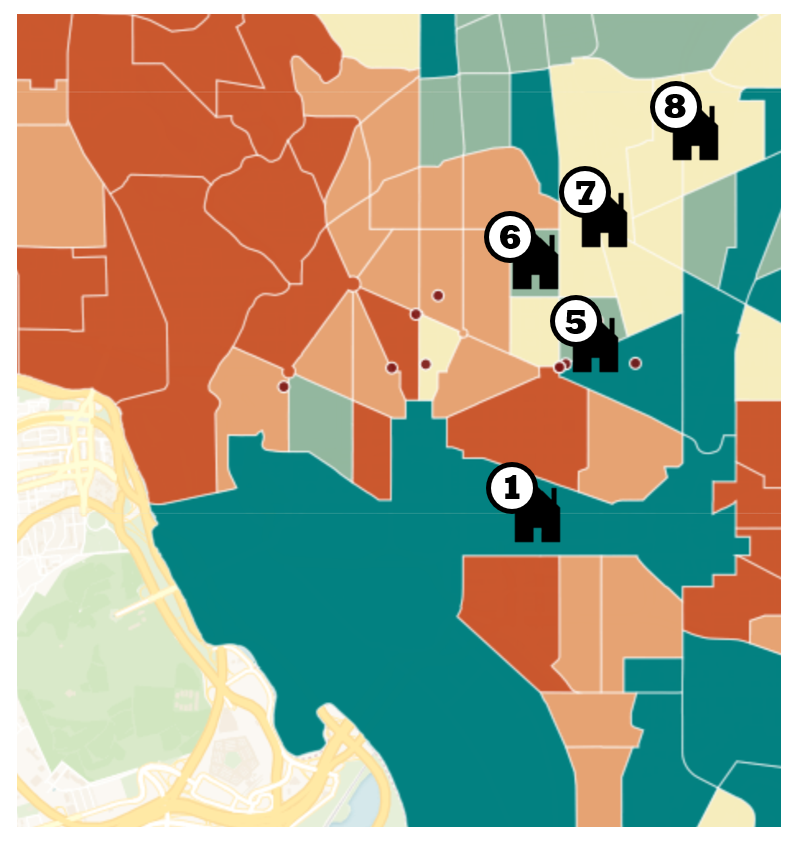
Overlaying the geography of DC with census records of median household income (circa 2000) creates a clear portrait of the dividing function of social class and its influence over the geographic distribution of homes. Higher-income households (represented by orange labels) tend to dominate the central and Northwest regions of the city, whereas lower-income households (represented by green labels) are isolated in the Northeast and Southeast regions of DC.

Overlaying median household income census data from 2000 on the four regions of Washington D.C. can help us conceptualize the geographic divisions of class and socioeconomic status in D.C.
This linkage between income and the geographic distribution of households parallels the experience of Lydia in “Lost in the City” and her passage from the lower income neighborhoods of Northwest DC (located along the fringes of the region) to her cushioned, upper-class neighborhood in the Southwest side of the city.
By mapping Lydia’s gradual transition from her childhood residences to her privileged life in the Southwest, we can see the overlap between the geography, the social factors, and the personal meanings that influence the construction of home. Serving as another lens through which to view the changing nature of home, social class informs our understanding of Lydia’s displacement from her childhood homes and, furthermore, deepens the division between her past experiences and her present identity as a member of the upper class.
Ultimately, the geographic distribution of home in “Lost in the City” directly mirrors the tension between upward social mobility (as represented through socioeconomic status) and its restructuring of origin and personal identity.
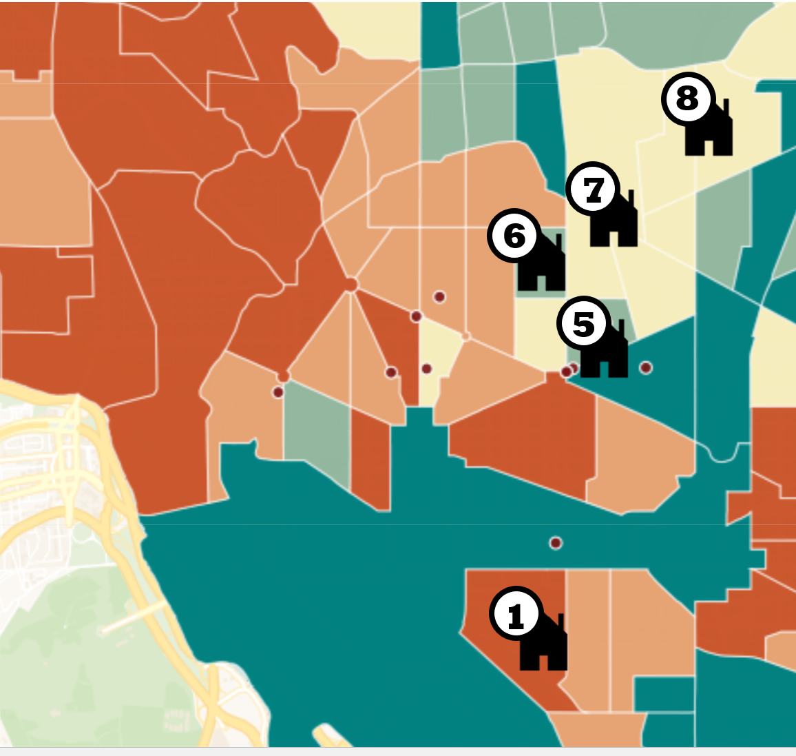
A zoomed-in version of the previous graph allows us to compare the socioeconomic distribution of Lydia’s town house (1) and her childhood homes (5, 6, 7, 8). The numbered labels of the homes are linked to their order in the mapped taxi route (above).
Sources:
Masek, J. G., F. E. Lindsay and S. N. Goward. “Dynamics of Urban Growth in the Washington DC Metropolitan Area, 1973-1996.” Landsat Observations, International Journal of Remote Sensing, vol. 21, no. 18, 2000, pp. 3473-3486. DOI: 10.1080/014311600750037507. Accessed 13 Mar. 2018.
Neighborhood Data. Neighborhood Info DC. April 2019. http://www.neighborhoodinfodc.org/ Accessed 13 Mar. 2018.
Washington DC: Our Changing City. Urban Institute. https://www.urban.org/features/our-changing-city-collection Accessed 13 Mar. 2018.
Photos:
Aerial Photograph of Pennsylvania Avenue in Washington, DC including the District Building and the Post Office Building. 1923. US National Archives. research.archives.gov/description/7851119. Accessed 14 Mar. 2018.
Maps:
All maps were compiled using Google Maps and Carto, with additional editing in Microsoft Word.
To learn more about the literary significance of taxi transportation in Lost in the City, considering exploring our CARS, CABS, AND THE SPACES THEY CONSTRUCT page.